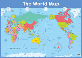
World maps are beneficial and serve the needs of various individuals, organizations, and industries. Here are some examples of who might need world maps:
Students and educators: World maps are essential for geography classes, allowing students to learn about the continents, countries, and physical features of the Earth. Educators use world maps to teach concepts related to global studies, history, geopolitics, and environmental sciences.
Travelers and tourists: People planning trips or traveling to different countries often rely on world maps to understand the geographical layout, plan routes, and identify points of interest. World maps provide an overview of destinations and help travelers navigate unfamiliar territories.
Cartographers and geographers: Professionals in the field of cartography and geography create and study world maps. They use them to analyze spatial relationships, map different phenomena, conduct research, and develop geographic models. Cartographers design and produce maps for various purposes, including educational materials, atlases, and navigation systems.
International relations and diplomacy: World maps play a crucial role in understanding political boundaries, territorial claims, and regional dynamics. Diplomats, policymakers, and international organizations use maps to analyze geopolitical situations, negotiate treaties, resolve border disputes, and plan development projects.
Businesses and logistics: Companies engaged in global trade, shipping, or logistics rely on world maps for strategic planning, route optimization, and understanding market dynamics. Maps help businesses visualize supply chains, transportation networks, and potential market expansion opportunities.
Environmental scientists and conservationists: World maps are vital for understanding ecosystems, biodiversity, and environmental issues on a global scale. Conservationists use maps to identify protected areas, track migration patterns, monitor deforestation, and plan conservation strategies.
Researchers and analysts: Researchers in various fields, such as social sciences, economics, public health, and demography, use world maps to visualize and analyze data. Maps help researchers identify patterns, disparities, and correlations within and across regions, contributing to evidence-based decision-making.
Emergency management and humanitarian organizations: During crises or natural disasters, world maps provide critical information for emergency response and relief efforts. Humanitarian organizations use maps to identify affected areas, plan rescue operations, and allocate resources efficiently.
Media and journalism: Journalists and media professionals use world maps to visually represent global events, conflicts, or natural disasters. Maps enhance news reports, providing context and helping viewers understand the geographical aspects of the stories.
These are just a few examples of the wide range of individuals and organizations that can benefit from world maps. Ultimately, anyone seeking to explore, understand, or communicate information about the Earth and its features can find value in using world maps.


